Hurricane Imelda is eyeing Bermuda and Hurricane Humberto has already passed it but, the National Hurricane Center said early Wednesday, both are likely to bring dangerous conditions behind them to a significant stretch of the U.S. East Coast.
“Swells generated by Hurricane Imelda and Hurricane Humberto are affecting the Bahamas, Bermuda, and much of the U.S. East Coast. These swells are likely to cause life-threatening surf and rip current conditions,” the Miami-based center said.
The storms’ centers were several hundred miles apart, with Imelda swirling west-southwest of Bermuda and Humberto north-northwest of the British island territory. Imelda had maximum sustained winds of 90 mph and Humberto’s were 80 mph, making both Category 1 storms.
A hurricane warning stemming from Imelda was in effect for Bermuda.
Hurricane Imelda forecast maps
Imelda is forecast to bring “hurricane-force winds, damaging waves and flash flooding” to Bermuda late today, the center said.
“On the forecast track,” the center noted, Imelda’s core “will be near Bermuda this afternoon or evening and move away from the island by Thursday afternoon. Imelda is expected to be stronger, near Category 2 strength (96 mph) when it passes close to Bermuda late today. Imelda is then expected to become an extratropical low in a couple of days, with gradual weakening thereafter.”
NOAA / National Hurricane Center 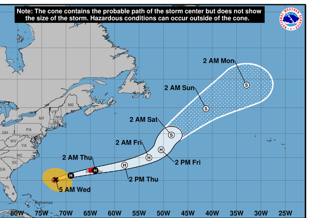
Hurricane Humberto forecast map
The center’s forecasters said “a faster motion toward the east-northeast is expected today” form Humberto until it merges with a developing frontal boundary (weather system edge) tonight. … Slight weakening is possible today, but Humberto is expected to remain a powerful cyclone until it merges with (the) frontal boundary tonight.”