A coastal storm is forecast to develop off the Southeastern U.S. this weekend, with heavy rainfall, strong winds, and coastal flooding expected to impact the East Coast through the beginning of next week.
The Interstate-95 corridor should be on alert, from the Delmarva Peninsula up into the Northeast and New England region.
As the storm moves up the coast, the National Oceanic and Atmospheric Administration’s Weather Prediction Center gives it a “slight” risk, or a level two out of four, for excessive rainfall for parts of the Mid-Atlantic on Saturday.
CBS News 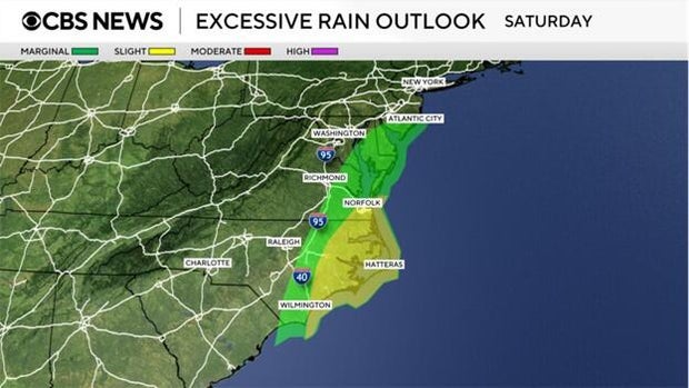
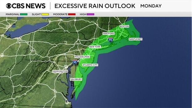
As the threat shifts farther to the north through the weekend, the excessive rainfall also moves northward, with the threat level remaining at a two out of four on the Weather Prediction Center’s scale.
CBS News 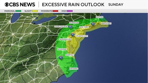
Models disagree on the timing and location of rainfall that this storm will drop, but current models show upwards of 3-5 inches of rain possible along the I-95 corridor.
CBS News 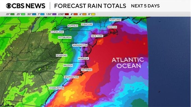
Why isn’t it called a “nor’easter” just yet?
To qualify as a nor’easter, the system must meet certain metrics from the National Weather Service.
One of those includes that the storm “develop in the latitudes between Georgia and New Jersey within 100 miles east or west of the East Coast,” according to the NWS. Forecast models currently disagree with where the system is developing, which is why we are holding off on this terminology until it is definitive.
Nor’easters are usually associated with winter weather, as these occur more frequently between September and April. Since this storm system will not produce hazardous weather that we typically see with more common nor’easters, coastal storm is the proper terminology at this time.
Regardless of what we refer to this as, a coastal storm will bring coastal flooding, heavy rain and strong winds to the East Coast over the weekend and start of next week. The threat appears to diminish after Monday as risk for excessive rainfall downgrades to a one out of four on the Weather Prediction Center scale.
CBS News